GEODEVICE GEOPHYSICS, RUSSIA
- SEISMIC EQUIPMENT
- ELECTROMAGNETIC EQUIPMENT
- MAGNETIC EQUIPMENT
- GAMMA RADIATION DETECTION
SEISMIC EQUIPMENT
1. Seismographs
Main features:
- All types of modern seismic acquisitions
- Easy combination of multiple DAQLinks
- Autonomous Recording
- Multiple data storage methods
- Built-in instrument and sensor testing
DAQLink-4 is a cutting-edge performance portable multichannel 24-bit digital seismograph. It can operate as a stand-alone unit for small and fast near-surface surveys, acquisition system for larger projects with online monitor and data quality control, as well as passive monitoring and automated event detection. Multiple trigger, synchronisation and data storage modes allow to use DAQLink-4 for all types of modern marine, land and borehole seismic acquisitions.
For more details visit: https://geodevice.co/main/seismic/station/daqlink4/
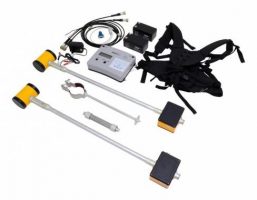
2. Towed LandStreamer for MASW, reflection or refraction surveys
Main features:
- Suitable for MASW, reflection or refraction surveys
- Adjustable sensors spacing
- Most compact and lightweight
- Compatible with any seismograph
- Custom configurations available
Towed LandStreamer is a receiver array, specifically designed for land seismic surveys. Towed techniques for land shallow seismic acquisitions significantly increase the efficiency and reduce the cost of the survey. Such methods as reflection, MASW, refraction would highly benefit from using towed streamer, comparing to the streamer with geophones, planted in the ground.
For more details visit: https://geodevice.co/main/seismic/landstreamer/
3. Sources
a. Energy sources Jack:
Main features:
- High charging rate
- Capability to control power consumption
- Remote control unit
- Portability
Jack energy sources ensure the operation of sparker and electrodynamic sources used in geophysical surveys in boreholes by methods of crosshole seismic testing (CST), vertical seismic profiling (VSP), vertical seismoacoustic profiling (VSaP) and others.
For more details visit: https://geodevice.co/main/seismic/sources/sparker/jack/
b. Borehole sparker Pulse
Main features:
- Easily replaceable electrode group
- Can be used in wells with diameters starting from 40 mm
- Reel with high-voltage slip ring
Pulse is a borehole sparker, developed for generating compressional P-wave energy in water-filled wells. This type of source is typically used for crosshole seismic testing (CST) and vertical seismic profiling (VSP) acquisitions. In combination with Jack energy source it provides stable signal shape with high frequency energy spectrum.
For more details visit: https://geodevice.co/main/seismic/sources/sparker/p-s-bh/
c. Borehole source of SH and P waves SHock
Main features:
- P and SH wave generation
- Suitable for CST and VSP
- High frequency repeatable signal
- Operations in dry and water-filled wells
- HV slip ring on the winch
SHock is a unique borehole source, which is designed for generating horizontally polarised Shear Waves (SH) and Compressional Waves (P) for reversed Vertical Seismic Profiling (VSP) and Crosshole Seismic Testing or Tomography (CST). Shock is an easy-to-operate high-repeatable seismic source, which can be used both in dry and water-filled wells in combination with Jack Energy Source.
For more details visit: https://geodevice.co/main/seismic/bhe/sh-bh/
d. Borehole source of SV-waves GEOSv

Main features:
- Light, powerful and easy-to-use
- Upward downward vertical shear waves
- No need to orientate
- Pneumatic locking system
GEOSv is the unique borehole source specifically designed for crosshole seismic testing (CST). Provided with a fast-locking pneumatic system, it allows to generate polarized vertical shear waves. This device is fully in accordance with international standard ASTM D7400-08. The operation of the GEOSv source is provided by the Jack energy sources.
For more details visit: https://geodevice.co/main/seismic/sources/sparker/geosv/
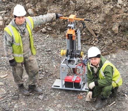
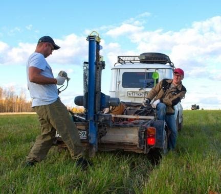
e. Hammers (Drop Weight Type)
AWD-33PS

Main features:
- P and S wave generation
- Compact design
- High energy of pulse
- Ideal repetition of impacts
- Hammers of different weights
AWD-33PS is a variant of seismic source of the “weight drop” type. The hammer is equipped with an inclined platform, allowing it to be installed at an angle of 45 degrees, and a special stop, adding stability in an upright position, what allows to perform survey on shear waves.
The striking mass (hammer) is accelerated with the aid of massive stretching springs that are armed by means of an electric winch powered by a car battery (65–180 A/h). The minimum period of operation of the source is 3 s.
For more details visit: https://geodevice.co/main/seismic/sources/hammers/33ps/
AWD-40PS
Main features:
- P and S wave generation
- Compact design
- High energy of pulse
- Ideal repetition of impacts
- Hammers of different weights
AWD-40PS is a variant of seismic source of the “weight drop” type. The hammer is equipped with an inclined platform, allowing it to be installed at an angle of 45 degrees, and a special stop, adding stability in an upright position, what allows to perform survey on shear waves.
The source AWD-40PS is mounted on a compact lightweight frame equipped with reliable wheel blocks. The delivery package of the source includes one hammer: 20, 33 or 40 kg. Hammers of another weights can be supplied additionally. The design of device allows hammer’s fast replacing in the field. The source can be used on a rugged terrain. The total weight of the source without battery pack is less than 120 kg. The energy of a single impact reaches 1000 J.
For more details visit: https://geodevice.co/main/seismic/sources/hammers/40ps/
AWD-33
Main features:
- Compact design
- High energy of pulse
- Ideal repetition of impacts
- Hammers of different weights
AWD-33 is a variant of seismic source of the “weight drop” type. The striking mass (hammer) is accelerated with the aid of massive stretching springs that are armed by means of an electric winch powered by a car battery (65–180 A/h). The minimum period of operation of the source is 3s.
The source AWD-33 is mounted on a compact lightweight frame equipped with reliable wheel blocks. The delivery package of the source includes one hammer: 10, 20 or 33 kg. Hammers of another weights can be supplied additionally. The design of device allows hammer’s fast replacing in the field. The source can be used on a rugged terrain. The total weight of the source with a battery pack and a 33 kg hammer is less than 100 kg. The energy of a single impact reaches 600 J.
For more details visit: https://geodevice.co/main/seismic/sources/hammers/awd33/
AWD-40
Main features:
- Compact design
- High energy of pulse
- Ideal repetition of impacts
- Hammers of different weights
AWD-40 is a variant of seismic source of the “weight drop” type. The striking mass (hammer) is accelerated with the aid of massive stretching springs that are armed by means of an electric winch powered by a car battery (65–180 A/h). The minimum period of operation of the source is 3s.
The source AWD-40 is mounted on a compact lightweight frame equipped with reliable wheel blocks. The delivery package of the source includes one hammer: 20, 33 or 40 kg. Hammers of another weights can be supplied additionally. The design of device allows hammer’s fast replacing in the field. The source can be used on a rugged terrain. The total weight of the source without battery pack is less than 120 kg. The energy of a single impact reaches 1000 J.
For more details visit: https://geodevice.co/main/seismic/sources/hammers/awd40/
4. Borehole Seismic Data Acquisition
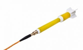
a. Hydrophone array WellStreamer
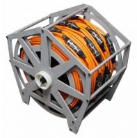
Main features:
- Specifically designed for HR borehole surveys
- Fast and simple infield operations
- High sensitive piezoceramic sensors
- Small diameter and light weight
- Compatible with any seismograph
WellStreamer is a borehole hydrophone array, specially developed for seismic acquisitions in the water-filled wells. We designed exceptionally easy to use and robust receiver array with high sensitive piezoceramic sensors for registering compressional (P) waves during VSP and cross hole surveys.
For more details visit: https://geodevice.co/main/seismic/bhe/h-array/
b. Multi-component downhole seismic array GStreamer
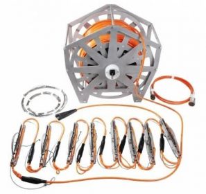
Main features:
- Multi-component seismic data registration
- Most compact and lightweight
- Works in wells with a diameter of 70 to 150 mm
- Remote clamping without air pump
- Works in dry and water-filled wells
Multi-component downhole seismic array GStreamer is the most compact on the market, cost effective solution for 3C borehole engineering and environmental surveys such as VSP and crosswell tomography. GStreamer is compatible with any modern seismograph, if you do not have any, DAQlink4 can be used for data recording.
For more details visit: https://geodevice.co/main/seismic/bhe/gf-array/
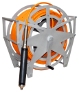
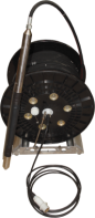
c. BGW winch for borehole seismic survey
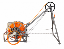
Main features:
- Electric drive
- Built-in sliding contacts
- Manual winch roller
- Integrated counterweight
- Manual winding option
BGW is specifically designed for seismic acquisitions in relatively deep wells, when cable and borehole equipment weight do not allow to perform convenient and safe operations.
Even with a borehole depth of 100 m, a standard coaxial wire line of a 10 mm2 cross section will weigh several tens of kilograms. At depths of several hundred meters, the use of a power cable with a large cross section of the core is required to balance the energy loss at the ohmic resistance - work with such a line is possible only with the use of BGW winch.
For more details visit: https://geodevice.co/main/seismic/bhe/bgw/
d. Seismograph TELSS-VSP for borehole surveying
Main features:
- Telemetry system
- ADC 32 bits
- High-quality anchoring arm
- Anchoring arm stops automatically when force rating is reached
TELSS-VSP telemetry borehole seismic acquisition system is designed for VSP, polarization VSP, uphole and crosshole surveying.
The mobility of the system allows the use of it in boreholes as deep as 100 meters (and even more).
For more details visit: https://geodevice.co/main/seismic/station/telssvsp/
5. Seismic Software
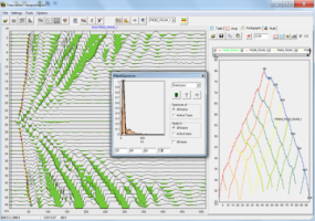
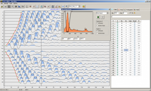
RadExPro

Main features:
- 2D/3D High resolution marine data processing
- Shallow seismic and VSP data processing
- 2D/3D marine and onshore data quality control, including real-time
- CPU and GPU parallel computations
- Flow replication, batches and queues for efficient processing of large volumes
- User-friendly Windows based software
RadExPro is flexible, state-of-art processing package, suitable for HR/UHR marine data processing, land shallow seismic data processing (refraction, reflection, MASW and VSP), as well as large-scale data QC, including Real-Time and fast-track processing.
For more details visit: https://geodevice.co/software/seismic-software/radex/
ZondST2d — 2D seismotomography interpretation (refracted waves)
Main features:
- Simultaneous picking of different types of waves
- Data processing is optimized with respect to simultaneous use of P and S refracted waves
- Recovery algorithm of velocity anisotropy distribution
- MASW
ZondST2D is designed for 2D interpretation of seismic tomography data on refracted and reflected waves (land, cross-borehole and water variants).
For more details visit: https://geodevice.co/software/seismic-software/zondst2d/
ZondST3d — 3D seismotomography interpretation (refracted waves)
ZondST3d is designed for three-dimensional interpretation of seismic tomography data on refracted waves (land, cross-borehole and water variants).
In geophysics, the term seismic tomography is known for a long time. This is due to the fact that one of the main problems in seismology — the inverse kinematics. It consists of determination the velocity structure at a known time path of the refracted waves from source to receiver. Cross-borehole seismotomography is one of the most popular methods in engineering geophysics; it is used for detailed determination of structures’ velocities in interwell space.
For more details visit: https://geodevice.co/software/seismic-software/zondst3d/
ELECTROMAGNETIC EQUIPMENT
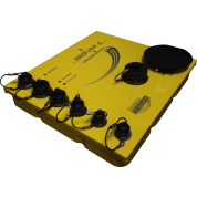
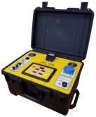
ARMT-5 — 5-channel 16/24-bit broadband EM system
Main features:
- Large set of methods
- Frequency bandwidth 0.1 Hz–1 MHz
- 5 channels of registration
- Programmable external amplifiers
- Built-in data processing and visualization
- Automatic calibration
ARMT-5 complex is designed for implementation of a variety of electric survey methods: AMT, CSAMT, CSEM, RMT, CSRMT. Its wide frequency range (0.1 Hz–1 MHz) makes it possible to apply this tool to explore depths from first meters up to several kilometres for wide range of targets.
ARMT-5 recorder allows one to visualize data in real time in both time and frequency domains. To quality control, a robust estimator of tensor and scalar transfer functions (impedance and tipper) is built-in. The receiver has several useful features for a controlled source EM exploration. The receiver is equipped with a built-in sine signal generator for automatic calibration (including calibration of magnetic sensors) and programmable external amplifiers for magnetic and electrical sensors (gain: 1–256). Sophisticated functionality, application of the most up-to-date element base, good-quality connectors and case, large color screen, fast interfaces for downloading data from SSD drive, and other technical solutions make ARMT-5 modern, convenient and versatile broadband electromagnetic tool.
For more details visit: https://geodevice.co/main/electric/armt-5/
FastSnap TEM/TDEM
Main features:
- High processing speed
- Multichannel measurements
- Scanning measurements in motion
- Automatic measurements, processing and interpretation
- Equipped with complete set of software
FastSnap is a multichannel automatically-controlled telemetry complex that ensures TEM/TDEM, frequency sounding, induced polarization, and direct current techniques. The system is by far the most advanced in its class offering the highest technical specifications and most comprehensive software package along with an affordable cost. The software streamlines all aspects of advanced automated ground TEM survey.
FastSnap allows advanced users to produce results at the highest professional level. The system is truly new benchmark for ground based TEM instruments.
For more details visit: https://geodevice.co/main/electric/fastsnap/
Electromagnetic induction compact profiler GEOVIZER
Main features:
- Capability to perform a custom calibration
- Calculation of apparent resistivity and signal phase
- Lightweight and portable
Multipurpose compact profiler GEOVIZER implements the method of induction multi-frequency mapping and enables to resolve the problem of fast and contactless surveying of the Earth. As a result of corresponding studies, it becomes possible to obtain spatial distribution of the level of secondary signal from the medium to a up to 3 m depth. The signal level allows for the evaluation of VES. Local high-contrast variations in the medium (metal objects, cavities, waterings with highly mineralized solution) are particularly trackable. More conductive objects (tunnels, bunkers with wet walls, pipes, etc.) in less conductive ground are also a good target for GEOVIZER.
For more details visit: https://geodevice.co/main/electric/gv/
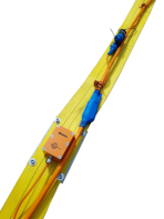
System for electromagnetic profiling AEMP-14
Main features:
- enhanced calibration provides profiling at 14 frequencies
- simplified functionality of the control program
- visualization of maps and profile curves
- advanced tapered connection for the antenna unit
Multifrequency complex AEMP-14 is the final version of the three-coil induction system for electromagnetic profiling.
The principle implemented in the instrument allows to measure the distribution of apparent resistivity in the soil at a depth of up to 10 m. Equipment shows the best results in conductive media. Also good targets for it are more conductive objects (tunnels, underground shelters with wet walls, pipes, etc.) in less conductive soil.
AEMP-14 allows profiling on any set of 14 fixed frequencies in the range of 2 500 – 250 000 Hz, including with automatic referencing of the measurement point to global coordinates.
Ease of operation allows just one person to work with the instrument. AEMP-14 measurement results are visualized in real time on the Pocket PC screen, data and control signals are transmitted via Bluetooth. Upon completing the work, data is downloaded to a PC for further processing and visualization of the result in the form of maps or profile curves. Depending on the number of frequencies used, the survey speed can vary from 2 to 30 km/h (with a density of 2 m on the profile).
For more details visit: https://geodevice.co/main/electric/aemp-14/
MAGNETIC EQUIPMENT
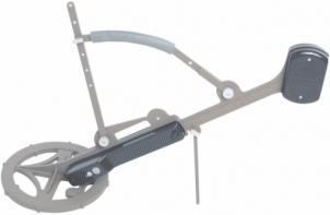
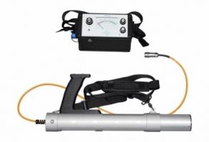
Cesium magnetometer QuantumMag
Main features:
- Very fast – up to 10 readings per second
- Effective in high-noise conditions
- Built-in GLONASS / GPS module
- Lightest and most portable in the World
- Li-ion battery included
- Can be fixed by shoulder belt or backpack harness
QuantumMag is one of the most advanced and light-weight versions of high-precision cesium vapour magnetometers on the market. The system allows one to measure the Earth’s total magnetic field with highest accuracy and rate. The device can be used as a rover hand-held magnetometer or autonomous base station. Data can be either stored in the built-in memory or transferred to a remote PC in real-time. The implementation of noise-free sampling algorithms enables the fulfilment of magnetometry surveys in the areas characterized by high level of industrial noises. Automatic coordinate determination of measurement stations as well as time synchronization between a rover magnetometer and a base station are provided by the built-in GLONASS / GPS receiver.
QuantumMag can be used as a deep metal detector and utility locator due to its high measurement rate and graphic data presentation through the built-in console display. This makes it perfectly suitable for the unexploited ordnance (UXO) detection and geotechnical studies.
The unit can be fixed either at the backpack harness (conventional magnetometry surveys) or at the shoulder belt (e.g. for UXO and utility detection) depending on the selected measurement technique.
For more details visit: https://geodevice.co/main/magnetometers/quantummag/
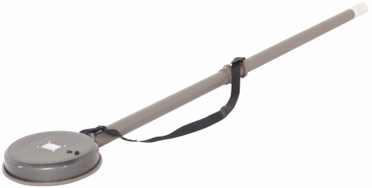
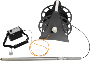
Overhauser magnetometer MiniMag
Main features:
- Lightest and the most portable in the World
- Wide range: 20 000 ÷ 110 000 nT
- High sensitivity: 0.01 nT
- Built-in GNSS receiver
- USB and RS232 for PC or external GNSS receiver connection
- Li-ion battery included
MiniMag — is the most advanced and lightest Overhauser magnetometer in the World. The instrument is intended for high-precision measurements of the Earth’s total field. MiniMag could be deployed as both rover hand-held magnetometer and autonomous or remote base station (BS).
Built-in and external GNSS receiver
Integrated multi-system GPS/GLONASS GNSS receiver enables automatic coordinate gridding of measurement stations and time synchronization with the base station. In cases when the connection of an external receiver is required, MiniMag can provide it using standard NMEA 0183 protocol via RS-232 connection.
Reliable instrument for magnetic observatories
High sensitivity and outstanding absolute accuracy (less than 0.1 nT) alongside with high sampling rate make MiniMag an excellent tool for the equipping of magnetic observatories. Real-time data transfer can be realized via either USB or RS-232 interfaces. An external GNSS receiver installed outside can provide the accurate time synchronization in any magnetic observatory.
Display and beeper
Both text and graphic data presentations are available on the built-in display of MiniMag. Convenient signal quality estimation is realized using sound beeper. Such user-friendly interface makes the magnetometer very easy to use for the real-time UXO and utility detection.
Metrology – guarantee of high accuracy
Each particular MiniMag has its own Certificate issued by authorized organization based on the testing in the entire operation range in the certified magnetic induction measure. We check such parameters as noise RMS; sensitivity and orientation error. Metrological Certificate confirms the instrument quality and guarantees the reliability of collected data.
Reliability and Warranty
Our R&D specialists have big experience in magnetometry surveys, that is why we understand that field instruments must be very reliable whereas the maintenance and repair must be fast and simple. All of our magnetometers are provided with 3-year Warranty and our technicians are ready to assist you if any problem arises.
For more details visit: https://geodevice.co/main/magnetometers/minimag/
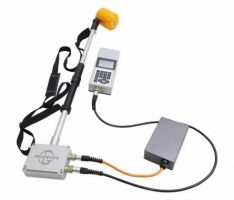
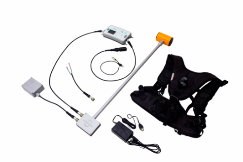
Overhauser gradiometer GradiMag
Main features:
- Based on Overhauser effect
- High resolution
- Stable in time readings
- Can be used with GPS
GradiMag — is a modern, high precision two-channel Overhauser total-field magnetometer / gradiometer. Its innovative design allows to deploy the system as a rover magnetometer, walking gradiometer or base station. As being equipped with an external GLONASS/GPS receiver, Gradiometer is perfect for archaeology surveys and geotechnical studies when target objects are located close to the surface with significant total field gradient values. Moreover, for gradient survey data analysis there is no need to remove the effects of daily magnetic drifts (diurnals). Thus, the using of base station data may not be necessary.
Due to the outstanding sensor stability GradiMag provides extremely high resolution. Beeper signalization makes the system very convenient for the purposes of utility detection in real-time. Each particular GradiMag has its own Certificate issued by authorized organization based on the testing in the certified magnetic induction measure.
MariMag - Marine magnetometer
Main features:
- Maintenance free Overhauser sensors
- High sensitivity and accuracy
- Built-in compass, accelerometer, leak detector, pressure and humidity sensors
- Lightweight and portable
MariMag is high sensitive, accurate and small size system for magnetic surveys both in shallow and deep water. Precise sensors with stable specifications as well as system module construction allow us to arrange both longitudinal and horizontal transverse gradiometers very easy. Special software from the equipment set can be installed at any personal computer. The software is intended for the equipment management and control, as well as data recording and visualization, their upload in specified file formats.
For more details visit: https://geodevice.co/main/magnetometers/marimag/
Portable Magnetic Susceptibility Meter PIMV
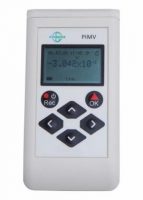
Main features:
- Lightweight and portable
- High sensitivity - 1x10⁻⁷ SI units
- 4 measuring modes
- Built-in GPS/GLONASS
- Bluetooth and USB
- Voice recording
Portable Magnetic Susceptibility Meter PIMV is designed to measure the magnetic susceptibility of rocks in field on outcrops, samples and cores from boreholes. The device is used in geological mapping, petromagnetic studies and solves the problem of rocks and ores differentiation in accordance with their magnetic susceptibility values with sensitivity up to 10-7 SI.
For more details visit: https://geodevice.co/main/magnetometers/pimvm/
Software for Gravity/Magnetic Surveys:
ZondGM2D — New product for 2D gravity and magnetic interpretation
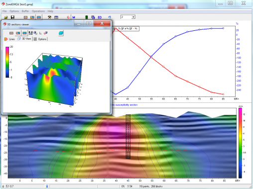
ZondGM2D new software for 2D gravity and magnetic survey combines the features of two predecessors ZondMag2D and ZondPGM. The program is designed for two-dimensional multiprofile interpretation of gravity and magnetic land / boreholes / aero data.
ZondGM2D is a ready solution for the interpretation of gravity and magnetic survey data, and presents a wide spectrum of tools from mathematical modeling to the interpretation of field data. User-friendly interface and wide possibilities of visualization is the key for effective solving of geological tasks.
For more details visit: https://geodevice.co/software/magnetic-software/zondgm2d/
ZondGM3D — 3D gravity and magnetic
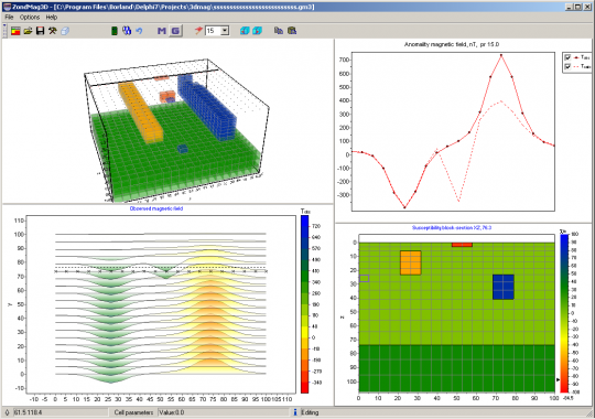
ZondGM3d program is desined for two-dimensional interpretation of gravity and magnetic data by (land and aero variants).
Anomalies of gravity caused of different dense heterogeneity are investigated in gravity survey. Influence of host rocks and surrounding topography is excluded by subtraction of the normal field and reductions. Magnetic survey is studied field generated by rocks that contain ferromagnetic minerals. Connection of measured on the surface field with magnetic properties of rocks allows to conclude about existence of magnetic objects.
ZondGM3d represents ready solution for gravity and magnetic methods, and solves wide range of problems from mathematical modeling to field data processing and interpretation. Convenient interface and variety of data visualization features allow to solve wide range of geological problems with maximum effectiveness.
ZondGM3d uses simple and clear data format which allows easily combining various systems of observation, including different variants of the topography setting up and other additional information.
Special graphics mode that allows to visualize data in the freandly form is presented.
For more details visit: https://geodevice.co/software/magnetic-software/zondgm3d/
GAMMA RADIATION DETECTION
Field scintillation radiometer SRP-20
Main features:
- Fast detection of gamma anomalies
- High sensitivity of measurements
- Portability and ease of use
- Arrow and sound indication
- Integration time adjustment
SRP-20 is the most advanced version of previously popular radiometers SRP-68 and SRP-97 and their analogue in terms of functional use and application domain. SRP-20, alike previous versions, is a scintillation radiometer and is designed to search for radioactive ores based on their gamma radiation, radiometric surveying of the terrain, radiometric testing of quarries and mine openings and detection of radioactively contaminated zones. The pedestrian and logging (analogues SRP-97K and SRP-68-02/03) versions are commercially available, which differ in the design of the detection unit case with identical metrological characteristics. Due to the presence of Bluetooth and USB interfaces, data can be transferred to a PC in real time. It is also possible to increase the time integration window in order to obtain stable data on anomalies that are close to background values.
Borehole scintillation radiometer SRP-20
Main features:
- Fast assessment of rocks’ natural radioactivity
- High sensitivity of measurements
- Portable and easy to use
- Adjustable averaging window
- Supplied with control source (Co-60)